
Forest Wildlife Management and Conservation
| Author: | LeRoy Humphries |
| Level: | High School |
| Content Area: | Biology, Environmental Science |
| Author: | LeRoy Humphries |
| Level: | High School |
| Content Area: | Biology, Environmental Science |
One of the most powerful tools forest managers can use today are Google Earth™ linked with a GIS1 program like ArcView™ to put together comprehensive diagrams of an area to be timbered. By using these tools, a forest manager can get an initial idea of what kinds of trees are located in an area, and the landforms that are present. This is a great way to analyze the area before timber harvesting operations commence, and can help in the development of a long-term management plan!
So, lets see how good you are at spotting different features in a forested area that might be of concern to a forest manager. Click on the link below to view a Google Earth image of Raven Rock State Park in Harnett County, North Carolina. See if you can find a major roadway in the area, the river, a stream that feeds into the river, an area that has been clearcut, an area that has been replanted with the trees in straight rows, and a field. Can you think of any other areas that might be important?
Once you have finished, use this link to see the area up close using Google Earth. This image was most likely taken during the winter months. How can we tell this? Believe it or not, we can even use satellite imagery to determine what plant types are found in an area! Different plants have different amounts of photosynthetic pigments, so they absorb different wavelengths of light while reflecting others. By careful analysis of images take from satellites we can tell what kinds of trees are found in our forest AND get an idea of the percentages of each! We can also compare images taken at different times of the year.
Now take a look at this location.
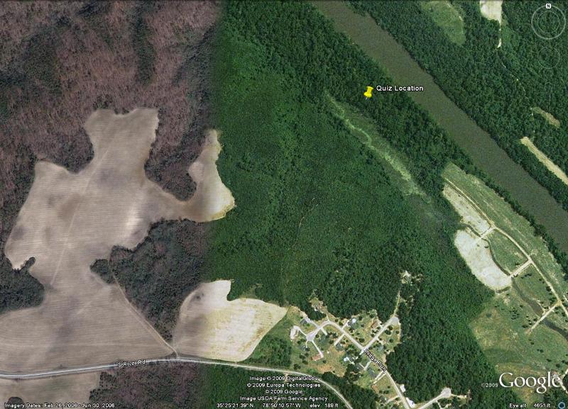
See the difference between the two sides of the image? Google Earth uses many different images of parts of the Earth's surface to create the big picture composite image. Careful analysis of an image can tell us what time of the year the image was taken. The image above is a composite of two images taken in different seasons. The left side was taken during the winter months, as indicated by the lack of greenery in the photo. The right side was taken during the summer months, and has considerably more green area, indicating that the trees are full of leaves. Now take a look at the quiz below. See if you can pick out some of the more important features in the forest that you would have to be concerned with to harvest timber here.
1A geographic information system (GIS), or geographical information system captures, stores, analyzes, manages, and presents data that is linked to location. Technically, GIS is geographic information systems which includes mapping software and its application with remote sensing, land surveying, aerial photography, mathematics, photogrammetry, geography, and tools that can be implemented with GIS software.
Address: Campus Box 7006. Raleigh, NC 27695 Telephone: 919.515.5118 Fax: 919.515.5831 E-Mail: KenanFellows@NCSU.edu